Charles City area remains under flood warning
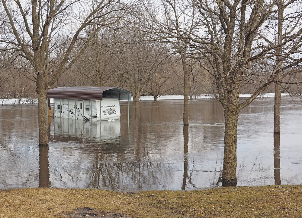
This travel trailer parked on property near the end of Cedar Crest Drive, northwest of Charles City, was never intended to be amphibious, but the rising Cedar River had other ideas. Press photo by Bob Steenson
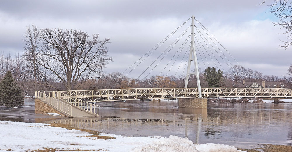
Ducks and other waterfowl are the only ones with access to the west entrance of the cable pedestrian bridge after the Cedar River rose high enough to overflow its banks and cover the area. Press photo by Bob Steenson
By Bob Steenson, bsteenson@charlescitypress.com
The Charles City area remains under a flood warning, although the Cedar River began to fall Sunday and was expected to continue dropping through midweek.
“Snow melt and recent rainfall continue to lead to minor flooding along the Cedar River near Charles City,” the National Weather Service said Sunday. “Some ice jamming remains possible, which could lead to rapid fluctuations in river levels.”
The Floyd County Engineer’s Office warned late last week that county gravel roads were soft and advised large trucks to stay off them.
“Drivers of all vehicles should use extreme caution when on gravel roads as conditions are rapidly deteriorating, making travel hazardous in many areas,” the Engineer’s Office said.
Several people who live in the country commented on social media that their usual routes to and from their homes were blocked, either by flooded roads or by roads that had been barricaded because of washouts or other problems.
The Charles City School District announced that it wouldn’t send school buses down roads that were questionable, and said it would notify students’ families each day if a bus route was not operating.
Families with students on a non-operating bus route had the options of driving the children to school themselves, having the district send a driver to pick up the students when it is safe, or having the students marked excused for the day.
The National Weather Service advised people traveling through flood-prone areas to keep aware of the latest river forecasts. It also repeated the mantra that has become common in flooding situations — “Turn around, don’t drown!” — reminding drivers to not drive through flooded roads, because it takes only 2 feet of water to float most automobiles, including sport utility vehicles.
The river had reached moderate flood stage in Charles City — 15 feet — over the weekend and crested at 15.8 feet at 2 p.m. Saturday.
It then fell to 14.7 feet at 7 a.m. Sunday, when it began to rise again. As of 4:30 p.m. Sunday it had reached 15.4 feet and was beginning to drop again, according to the National Weather Service.
NWS predicts the river level will continue to drop to normal through the early part of the week, before starting to rise again on Wednesday and possible again reaching minor floor stage — 12 feet — by Saturday.
The area forecast is for continued warmer-than-average temperatures in the mid- to high 40s through the week, reaching into the 50s by weekend, meaning continued quick snowmelt.
Residents in parts of southwestern Iowa were forced out of their homes Sunday as a torrent of Missouri River water flowed over and through levees.
Heavy rainfall and snowmelt have led to dangerously high water in creeks and rivers across several Midwestern states, with the Missouri River hitting record-high levels in many areas. At least two deaths were blamed on flooding, and two other men have been missing for days.
While river depths were starting to level off in parts of Nebraska on Sunday, the water is so high in many places that serious flooding is expected to remain for several days. And downstream communities in Kansas and Missouri were bracing for likely flooding.
In Iowa, the Missouri River reached 30.2 feet Sunday in Fremont County in the state’s far southwestern corner, 2 feet above the record set in 2011. People in the towns of Bartlett and Thurman were being evacuated as levees were breached and overtopped.
County Emergency Management Director Mike Crecelius said it wasn’t just the amount of the water, it was the swiftness of the current that created a danger.
“This wasn’t a gradual rise,” Crecelius said. “It’s flowing fast and it’s open country — there’s nothing there to slow it down.”
Thurman has about 200 residents. About 50 people live in Bartlett.
Lucinda Parker of Iowa Homeland Security & Emergency Management said nearly 2,000 people have been evacuated at eight Iowa locations since flooding began late last week. Most were staying with friends or family. Seven shelters set up for flood victims held just a couple dozen people Saturday night.
In Nebraska, the Missouri River flooded Offutt Air Force Base, with about one-third of it under water on Sunday. Spokeswoman Tech. Sgt. Rachelle Blake told the Omaha World-Herald that 60 buildings, mostly on the south end of the base, have been damaged, including about 30 completely inundated with as much as 8 feet of water.
Hundreds of people remained out of their homes in Nebraska, where floodwaters reached record levels at 17 locations. The Nebraska Emergency Management Agency highlighted some remarkably high crests. The Missouri River was expected to reach 41 feet in Plattsmouth on Sunday — 4 feet above the record set in 2011. The Elkhorn River got to 24.6 feet Saturday in Waterloo, breaking the 1962 record by 5½.
The rising Mississippi River also was creating concern. The Mississippi was already at major flood level along the Iowa-Illinois border, closing roads and highways and swamping thousands of acres of farmland. Moderate Mississippi River flooding was expected at several Missouri cities, including St. Louis.
Flooding has also been reported in Minnesota, South Dakota and Wisconsin. In Green Bay, Wisconsin, officials said residents who evacuated their homes could return now that floodwaters have receded there.
— The Associated Press contributed to this story.


Social Share